
Buckingham Mysteries: Maynards Church, Part II
 Liberty Baptist Chapel Church.
Courtesy Liberty Chapel Baptist Church – 1775 Facebook Page.
To catch up on the discussion of Maynards Church, click here: Buckingham Mysteries: Maynards Church
Following my post on August 12, 2019, I received many comments and emails concerning the location of Manyards Church and John Patteson’s land in today’s Appomattox County, as well as information about the Nicholas Maynard, probably the man behind the church’s name. Combining these, we have a much bigger and better picture of this neighborhood in early Buckingham County.
Slate River Ramblings follower Karen Williams supported the idea that Maynards (or Maynard’s) Church shared a location with Liberty Chapel Baptist Church at Bent Creek in Appomattox County, asking, “Couldn’t Liberty Baptist have morphed out of Maynard’s Corner/Chapel.”
Just as Rev. Rene Chastain and the congregation of Buckingham Baptist Church took over the structure of the original Buckingham Church, it is entirely possible that a similar transition happened at Bent Creek. References in the book Appomattox County Virginia, 1845-2000 offer some details:
Liberty Chapel Baptist Church dates its origin back to 1775 when a band of believers met at Maynards Corner, five miles south of Coppersville (now known as Bent Creek), organized a Baptist Church calling it Maynard’s Church. The church was used by the Baptist, Methodist and Presbyterians. In 1830 the church was known as Harmony Baptist Church. In 1840 it was re-organized and named Liberty Chapel, the name it carries today. (p 32)
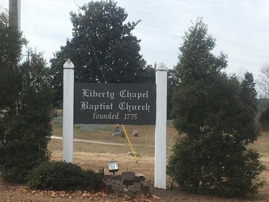
Liberty Baptist Chapel Church.
Courtesy Liberty Chapel Baptist Church – 1775 Facebook Page.
The first 55 years of Liberty Chapel Baptist Church’s history are very sketchy. We do know that in 1775, a small band of believers met at Maynard’ s Corner, which was five miles south of Coopersville (now Bent Creek) and organized a Baptist Church. In letters, the church is referred to as Maynard’s Liberty Chapel. (p 38)
~
Slate River Ramblings reader Les Campbell added, “The present site of Liberty Chapel is about 1.75 miles (as the crow flies) from the 1781 property boundary of John Patteson.”
Kathie Phelps Mann contributed an important clue, “You also see it listed in old patents and tax lists as “Mainyards” Church- say it with a French accent and you realize it was a phonetic spelling of Maynard.” Kathie’s Phelps family lived in the neighborhood.
~
Now we have a new mystery. Was Bent Creek previously known as Coppersville or Coopersville?
Coming next Buckingham Mysteries: Maynards Church, Part III


L. D.,
Good to learn that you had an informative visit to Liberty Chapel. Thanks for leaving your findings here for all to read in the future.
Joanne
Joanne, I looked at the Buckingham/Appomattox map again this morning and Maynards Creek is one of the creeks that runs into Davids Creek. If you go on the website for Buckingham Appomattox Map 1863 Library of Congress you can blow up the map and see all. You may want to share with others as you can see the location of the church and the creeks.
Thanks for tip!
Joanne
Joanne, I visited the church today. A Mr. Reynolds lives across the street from the church. He told me the current church is not the original. The original church was close by the current church and his grandfather purchased the original property and took down the old church. He said he remembered working tobacco in the field the original church was in. The only thing remaining from the original church is foundation stones and possibly stones from the chimney. The location of the old church was close to a spring most likely the water was enjoyed by those attending and the horses.they used to bring them to church. The church is on Liberty Chapel road. The land was purchased from a Napoleon Smith. I would think the transition from old to new was getting the church to front on the road but I don’t know that.
Are any of the original foundation stones/chimney still visible? That would certainly pinpoint it exactly (imagine the potential finds a metal detector/ground penetrating radar survey might turn up). Thanks for that additional information. Is the spring still active?
Joanne, I did a little research and find a few other items to be considered. I always thought Bent Creek was previously known ad Diuguidsville and goes back to 1792, Mr Diuguid was Patrick Henry’s cousin.
John Patteson was a surveyor in Buckingham later to become Appomattox in 1845. He did many surveys to include New Canton. John Patteson also shared a property line with Nicholas Maynaird and was on the east branch of Davids Creek. Davids Creek runs into the James known as the Fluvanna during those days. This is according to Buckingham County,Virginia Surveyor’s Plat Book 1762-1858. The church is in the same neighborhood as Patterson/Maynaird property and was referred to as Liberty Chapel on the Civil War Map of Buckingham /Appomattox Counties dated 1863. This is the same area my family lived in during the same period. More information can be found about Patteson etc.under Virginia Heritage….the Thornhill Family and of Thomas Bocock.
L. D.,
Many thanks for this additional information about John Patteson and Liberty Chapel.
Joanne