

Anyone who has conducted research in Buckingham County knows all about “brick walls” and apparently unsolvable mysteries. From time to time, I will post a photo of a house or an individual or a family in the hopes that someone can make a positive identification of the image. Here’s my first mystery image.
Driving in the general vicinity of Sharps Creek or Diana Mills (I don’t know precisely where I was), I saw this substantial dwelling, complete with requisite Buckingham slate roof. This is my Harris family’s old stomping ground.
Can anyone identify it? If you can identify a family who owned the house at one time (or now), please let me know approximately the decade and century as well as the family surname. Thanks!

Photo by Joanne Yeck (2005)
One of the nineteen Buckingham County churches mentioned in Thomas Baldwin’s Gazetteer of the United States (1854) is Trinity Presbyterian Church. Unlike many of the structures surveyed in the 1930s for the Virginia Historical Inventory, Trinity not only survived the 20th century but is still maintained today.
In 1937, VHI field worker, Rosa Garnett Williams, wrote, “This is a very old church and a very well built one. . . . This building is beautifully located on the brow of a hill off of the highway.” Founded in 1827, near New Canton, Buckingham County, Trinity Presbyterian Church “was built with a gallery so that the slaves in the community would have a place to worship,” wrote Mrs. Williams. “Many prominent families of Buckingham have worshiped at this church namely: the Nicholases who were some of the first people of the state, Guerrants, Fountains, Davises, and many others.”
Two of the “many others” in the congregation were my ancestors John M. Harris (1785-1874) and his second wife and the mother of all of his children, Evelina Ann Moseley (d. 1841). Evelina Ann had many family members who lived near Buckingham Court House and attended Maysville Presbyterian Church.
Note: Use the search function in the right hand panel to locate previous posts about the nineteen churches active in Buckingham County in 1854.
Update: Other church members include: Holman and Cocke.
In Colonial Virginia, the Church of England determined the shape of religious life. Whether Virginians were Anglican, dissenter, or nonbeliever, their taxes supported the established Church, and their attendance at services was expected. In addition to ruling religious life, the Church managed many of Virginia’s “social services,” which today would be assigned to government. Early Buckingham County was no exception, and its most influential men held the positions of Church Wardens and Vestrymen.
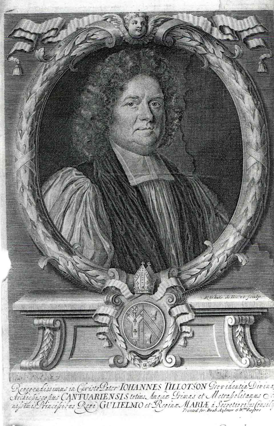
As in England, counties were divided into parishes, which handled the local business of the church. Each parish was served by a single minister, was governed by a vestry, and contained a mother church, often supplemented by two or more churches in outlying areas, which the minister served on successive Sundays. In the sparsely populated Virginia frontier these parishes could be enormous. By the mid-18th century, settlement increased, the population swelled, and the citizens of Albemarle County living south of the Fluvanna River (now the James) petitioned for a new parish. In 1757, Virginia’s General Assembly responded by creating Tillotson Parish, agreeing that “Whereas the parish of Saint Anne, in the county of Albemarle, by reason of the great extent thereof, is very inconvenient to the inhabitants . . . all the part thereof lying on the south side of said river, shall be one other distinct parish, and called and known by the name of Tillotson.” The parish was named for Rev. John Tillotson (1630-1694), pictured above, who served as Archbishop of Canterbury from 1691-1694.
In 1761, when Buckingham County was cut out of Albemarle, Tillotson Parish and Buckingham became one and the same entity.

Fry-Jefferson Map of Virginia, 1755.
When Joshua Fry and Peter Jefferson made their famous map, Buckingham County was still part of Albemarle County. The circles are plantations, and “Buckingham” has this designation. The triangles are courthouses. Note that Old Albemarle Courthouse is directly across the river from Peter Jefferson’s plantation, Snowden.
As many of you know, in 2011, Buckingham County celebrated its 250th anniversary. In 1761, it and its “twin” county, Amherst, were cut from a vast Albemarle County.
In March 1761, the Virginia House of Burgesses voted to divide the vast Albemarle County into three distinct parts, establishing a new county to the west and one to the south. The goal was to ease the “many inconveniences” the citizens of Albemarle experienced getting to the courthouse at Scott’s Landing, on the Fluvanna River. From the first day of May 1761, the new Virginia statute announced, all that part of Albemarle “which lies on the south side of the Fluvanna river shall be one distinct county, and called and known by the name of Buckingham.”
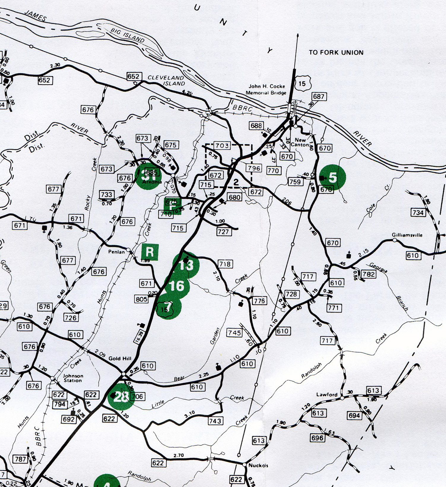
Here’s the first of a series of detailed maps of Buckingham County. This is the Northeast corner of the county. To the north is the James River and Fluvanna County. To the east is Cumberland County.
This detail includes New Canton (the river town just off Highway 15), Arvonia (the area where Buckingham slate was and still is quarried), Gold Hill (the name speaks for itself), and “blink and you’ll miss it” spots like Nuckols and Gravel Hill. Wikipedia calls them “unincorporated communities.”
The Buckingham Female Collegiate Institute was located in this part of the county. It was described as “just off the Richmond-to-Lynchburg stage route, and twelve miles from New Canton on the James River.”
On the left side of the map, the Slate River snakes towards where it flows into the James River. The Buckingham Branch Rail Road runs south towards Dillwyn.
If you click on the map, a separate image will open and you can enlarge any area you are interested in.
Note: This map was created c. 1989 and, therefore, is not completely current; however, change comes slowly to Buckingham so it remains useful.
Key for the “Points of Interest” in green, roughly from north to south:
31: Slate Quarries; 5: Carter G. Woodson Memorial; F: Fire Department; R: Rescue Squad; 13: Frances Redwood Educational Center; 16: Gold Hill Village; 7: Central Virginia Community Arts Center; 28: Old Buckingham Church
 photo by Joanne Yeck

Coz. Harry writes that during the restoration of Humanity Hall the presence of a young woman was seen in the very back room of the main floor. He suggests a Holman as a possible candidate for the specter.
Elizabeth Hales Holman (1814-1841), who married Ambrose Ford, died in childbirth or shortly thereafter. She was buried at Humanity Hall in what was once the rose garden in front of the house, her grave marked by a magnificent marble, table-top marker. As you can see by the photo, Elizabeth’s marker has seen better days.
Perhaps, she would like her grave site repaired and the roses reestablished.
Please send more ghosts stories or other candidates for the Humanity Hall apparition. There must be many Buckingham ghosts just dying to get five minutes of fame on the Internet!

As content builds up here at Slate River Ramblings be sure to make use of the search functions. You can search by keyword or by category by using the boxes in the panel on the right-hand side.
Just put in a word like “maps” or “churches” or “schools” or a surname you are interested in and you’ll get a page of search results like this sample for the surname Maxey. Try it!
Search results for ‘Maxey’

In 1833, in the north woods of Ohio, Oberlin Collegiate Institute opened its doors not just to men, but to women, as well. Founded by a Presbyterian minister and a missionary, Oberlin’s goal to train Christian leaders for the Western frontier was equalitarian across both economic and gender lines. Students labored in exchange for learning, opening the horizons of higher education beyond the limits of the upper class.
Following this isolated and rather shocking co-educational experiment, the Virginia General Assembly officially incorporated the Buckingham Female Collegiate Institute on January 13, 1837, making it the acknowledged first chartered college for women in Virginia, perhaps in the nation.
Between $27,000 – $36,000 has been estimated for the cost of the school’s construction, and it showed. Sitting on 120 acres of level meadow, the main, three-story building contained fifty-two rooms, including classrooms, music rooms, and an auditorium or chapel. The interiors were top quality, the main Hall paneled in walnut with carved cornices. Most, but not all, of the students boarded at school, and their rooms were appointed with walnut bedsteads and washstands.
This was Buckingham County at the top of its game. Cutting edge. Bold. Groundbreaking. These planters wanted their daughters educated . . . and in style.
Buckingham historian, Lulie Patteson brings the collegiate scene to life, in her typical romantic fashion: “Looking at a picture of the Institute and grounds of that day, one can easily call up a vision of the treasured young daughters of that period, strolling [with] graceful dignity along the walks or beneath the flower-twined archways in their leisure hours; clad in costumes that not only had cost many hours of dress-making skill, but many yards of material as well.”
In the coming months, we’ll continue to look at the men who conceived The Institute, the enriching impact it had on Buckingham’s culture, and the lives of some of the women who attended it.
 Miss Lulie Patteson
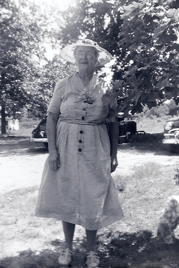
(Courtesy Gordon G. Ragland, Jr., Maxey/Patteson Family Collection)
Attempting to write the history of Buckingham County comes with significant challenges, but not insurmountable ones, and beginning in the 1930s, Mary Louise “Lulie” Patteson rose to the occasion, sharing her love for Buckingham and for the surrounding region in the local newspapers. Her devotion to Buckingham’s quickly fading, 19th-century past fueled a lifelong occupation.
Born in 1879, Lulie lived all of her days at the Patteson homeplace at Ransons. Her parents were Thomas Anthony and Antonia Maria (Tucker) Patteson. Thomas was thirty years Antonia’s senior; they were fifty-seven and twenty-seven when they married. Lulie was the eldest of their six children.
Lulie Patteson’s personal story is both distinctive and typical in Buckingham County. Her life reflects the hard conditions so many families faced in Buckingham after the Civil War and throughout the Great Depression; yet Lulie’s work ethic and her desire to serve others made her an outstanding citizen of her day. Her love for Buckingham and its history, coupled with the determination to write it down, distinguished her far beyond the confines of even her very long life.
In the coming months, I will borrow from Lulie’s work; I may quote her at length. I trust you will enjoy Lulie’s romantic and vivid prose as much as I do.
 The ruins of Nicholas Mills. Photo by Joanne Yeck

Buckingham County was not without industry. In addition to the mining of gold and slate the Gazetteer of the United States (1854), records that “There were 2 flour and grist mills, 3 saw mills, and 1 tannery.” The 1850 industrial census helps us identify the families behind the statistics.
One of the flour mills was operated by “R.C. Nicholas and Bros.” In 1850, their enormous water-powered mill employed ten men. Carroll M. Shepard owned the grist mill. The saw mills were owned by Nicholas & Aldridge, Samuel F. Putney, and Carroll M. Shepard. Collectively they employed seventeen men. S.F. Putney also employed one woman; there is no indication as to the nature of her work. William E. Worsham operated the tannery, employing three men. Over the course of ten months, they tanned 1000 sides of leather.
Those familiar with Buckingham County surnames will recognize these families. R.C. Nicholas also operated a store at the mill near where the Slate River flows into the James River. In 1850, S.F. Putney is described as a “lumber master.” Residing with him is an overseer, James Ferguson, and an engineer, Robert Layne. Living nearby the twenty-nine-year-old S.F. Putney, is the thirty-five-year-old Isaac B. Putney, millwright.


