

Photo by Joanne Yeck
In 1937, Elizabeth McCraw wrote two surveys about Planterstown for the Virginia Historical Inventory. One focused on the house once owned by the Gilliam family. Click here to read the 2013 post discussing that survey: Buckingham Towns: Planterstown.
The other survey, titled “Planterstown of 1798,” recounted the founding of the town. In 1937, Mrs. McCraw wrote: “A good deal of interesting information has been secured about a ‘would be’ town, chartered about 138 years ago, located at the foot of Woods Mountain at the Cut Banks on the Appomattox River. The only visible signs of the town are the remains of a few old vats.”
On January 15, 1798, The Virginia General Assembly passed on Act allowing a town to be created on 25 acres owned by Ichabod Hunter and John Epperson, lying at the Cut Banks in the County of Buckingham. William Perkins, Jr., Charles Yancey, John Johns, Joel Watkins, Daniel Moseley, Henry Flood, Nathaniel Lancaster, Robert Kelso, Anthony Winston and Stephen Pettus were named as trustees. Lots were to be laid off, ½ acre each, with convenient streets, and the town was to be called: “Planterstown.”
Eventually, Planterstown was laid out in four rows of lots, nine lots to each row. High Street, Wide Alley, Pact Street, Little Alley, and Wide Street divided the lots. Not very imaginative names, however, they served the new town’s commerce.
To be continued….
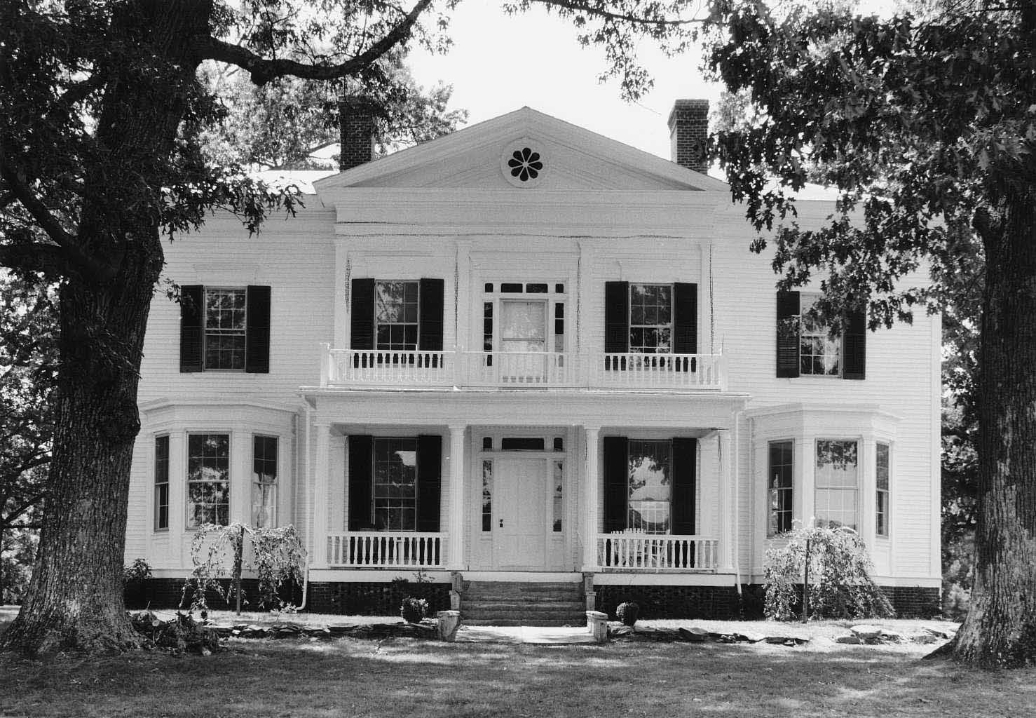
Woodside, Courtesy of Virginia Department of Historic Resources
In 1993, Woodside, which sits on a knoll overlooking the village of Buckingham Court House, was added to the National Register of Historic Places.
This two-story Greek Revival house was built in 1859-1869 for Dr. William M. Swoope and is a beautiful reminder of elegant, 19th-century living which few in Buckingham County could afford.
From 1871-1882, Woodside was the residence of Nicholas F. Bocock, a prominent local lawyer, and his heirs. He was the brother of Thomas S. Bocock, another Buckingham Notable.

Sketch by Margaret Allen Pennington
Salem United Methodist Church, Courtesy Historic Buckingham
In 1937, Garnett Williams surveyed the site of Salem Methodist Church for the Virginia Historical Inventory. Though the original church was no longer standing, Mrs. Williams suggested it dated from about 1750, writing: “The first Salem Church was located near Chastine Mill on the Rosney Road now known as route 623. . . . One very old lady of the community says she recalls, as a child, this building, and that in addition to the main part of the church there was a room with a chimney and a fireplace at one end of the building. Perhaps the pastor lived in this room.”
Buckingham County historian Lulie Patteson was one of the informants for this survey, as was Miss Edwerta Shepard, who died before the survey was recorded. In 1930, “Werta” Shepard, age seventy-five, was enumerated in the Curdsville District. Her occupation was farming.
While 1750 seems a very early date for the founding of the church, it existed in some form in 1839, when Samuel Shepard of Merry Oaks plantation wrote a letter discussing his slave, Tom. Shepard addressed his letter to “Brother” Spencer of Salem Church.
Click here for more about Samuel Shepard’s letter.

GOLD! GOLD! GOLD!
On July 30, 1833 the Editors of the Richmond Whig printed a letter from Daniel Guerrant concerning the abundance of gold in Buckingham County. It read as follows:
Sir—Mr. Thomas Morton & Co., digging on the west fork of Hunt’s Creek, about two miles north west of Buckingham Church, are getting frequently four or five dollars per day, to the hand. One day they obtained eight pennyweights, valued at 95 cents per dwt. Or about 7 or 8 dollars to each hand employed, in surface gold. A large quantity of Ore has also been dug up out of a pit adjacent to the branch that the surface gold has been obtained from. One man (engaged in mining,) supposed this ore worth 8 or 10 thousand dollars, or 7 or 8 dollars to the bushel. A mill will be erected to convert it to dust for the purpose of being washed. John Mosley & Co., have very lately commenced washing for surface gold, about three hundred yards south of Morton & Co., on the land of Stephen Guerrant. . . .
Beginning in the 1830s, numerous goldmines opened in Buckingham. To read more about them at Slate River Ramblings, type gold in the search box on the right and enjoy the results!

Silos at Slate River Mills, 2007, Courtesy Lee J. Dowdy
In April of 2014, Slate River Ramblings featured a post about Hocker’s Mill (a.k.a. Slate River Mills), one of the first and longest standing mills in Buckingham County.
For many years, the Dowdy family operated the mills, which they renamed Slate River Mills. In 1884, Napoleon B. and Judith L. (Murray) Dowdy purchased the property from Nathaniel Archer Dowdy and Willis J. Dowdy. Following Napoleon Dowdy’s death in 1896, Judith ran the mill for several years with the help of her oldest sons. They updated the mill and, in 1900, Judith headed the household, with ten of her eleven children living with her. Son Oscar A. Dowdy, then age twenty-two, was the miller.
In 1902, Judith moved to Roanoke with her youngest children, selling 25 acres (more or less), her dwelling house, and the mill to James L. Anderson.
Descendant Lee J. Dowdy commented: “The mill was located on what is now Old Mill Road, off of Slate River Mill Road. If you are heading west on Slate River Mill Road, (north, northwest of Dillwyn), Old Mill Road is on your left before crossing over the Slate River. The foundation of the mill is still there in a small copse of trees.”

The Cave at Snowden, Photo by David Spears
After the publication of “Thomas Jefferson Didn’t Sleep Here: The Cave at Snowden,” Slate River Rambling’s reader and former Scottsville resident, Ranny Moulton, recalled playing in the cave in Snowden’s bluff. In his youth, it was referred to as Napier’s Cave. According to local tradition, Civil War deserters hid there.
In 1930, William B. Napier, son-in-law of Richard Ward, lived adjacent Mary Belle Hancock who owned a significant percentage of what was once Randolph Jefferson’s Snowden. Richard Ward, William Napier, and Andrew Ward rented their land, possibly working the part of Snowden where the cave was located.
Is this William “Buster” Napier (b. 1906), son of Hatton Ferryman, William Joseph “Joe” Napier (1871–1947)?
Does another Slate River Ramblings reader remember Napier’s Cave?
Can anyone comment on this local legend of Confederate deserters?
 Ruins of Virginia Mills, photo by Joanne Yeck
Thomas Jefferson had many occasions to visit Buckingham County. As a young lawyer, he took cases that were based in Buckingham. In 1776, his only brother, Randolph, became heir to Snowden, located at the Horseshoe Bend at the northern tip of the county. And, in 1797, Thomas’ daughter, Maria, married John Wayles Eppes and they lived at Millwood in southern Buckingham.
In January of 1811, Thomas Jefferson made an unusual trip to Buckingham, to study the operations at Virginia Mills on the Slate River. There he met with owner Charles Alexander Scott and spent the night. The next day, Jefferson rode across northern Buckingham, crossing the James River at Scott’s Ferry. From there, he continued on to Warren and, then, to his home in Bedford County, Poplar Forest.
His memoranda for January 28, 1811 does not indicate that he purchased a mid-day meal. Perhaps, that day, he was entertained at Snowden by his brother and his wife, Mitchie (Pryor) Jefferson.
Learn more about Thomas Jefferson’s visits to Buckingham County in The Jefferson Brothers.
Last month’s post, Buckingham Post Offices, created a lively conversation about postmasters and postmistresses.
Slate River Rambling reader, Jeremy Winfrey, provided the following biography Samuel L. Burks, Jr. who was postmaster at Bolling’s Landing in 1879.
S. L. Burks, Jr.,Courtesy Sandra Moore
Samuel Lewis Burks Jr. (1848-1932), was the son of Samuel Lewis Burks Sr. and Martha J Staton. Samuel and his eight siblings grew up north of present day Route 652, near Bolling’s vast 19th-century tract, hence the Post Office’s name, Bolling’s Landing. This line of Burks helped populate the northern section of Buckingham into the 20th century, while others from this line removed to Nelson County. Samuel, Jr. married his neighbor, Alice Virginia Payne. According to a descendant, Samuel Burks not only ran the post office for a while, he also owned the boat and mules that ran from Paynes Landing (his sister’s home) to Richmond. Once the canal was discontinued, he moved to Charlottesville and built a large home and mill. They are both buried at Riverview Cemetery in Charlottesville, Virginia.

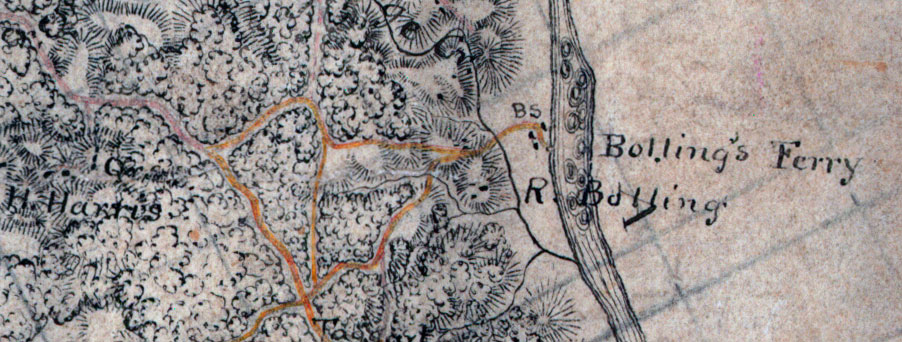
Henry St. George Harris, Bollings Landing, Buckingham County, Va.
During the 19th century, my Harris family, along with many others, received their mail at Bolling’s Landing on the Buckingham shore of the James River. It was located on land owned by Robert M. Bolling and Bolling’s Ferry appears on Jeremy Francis Gilmer’s Civil War-era map. See below.
Local historian Richard Nicholas described the location as “a little less than 1.5 miles upriver from the mouth of the Hardware River, a few hundred feet above where Little George Creek empties into the James River on the Buckingham side. The landing was directly across the river from the railway siding that is now called Paynes (Fluvanna County).”
Richard Nicholas also shared the fact that the diary of the Chief Engineer of the James River and Kanawha Canal includes a table listing all the locks on the canal. It places Bolling’s Landing seventy-four miles from Richmond, between locks #21 and #22.
Over the years, postmasters at Bolling’s Landing included John M. Brown, Thomas D. Kidd, Frank N. Maxey, Jr., and Samuel L. Burks. On February 4, 1880, mail delivery to Bolling’s Landing was discontinued and moved to Payne’s Post Office.
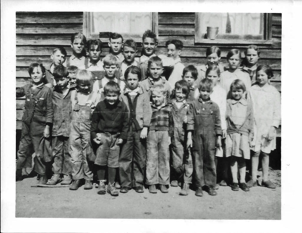
Beesville School, late 1920s,
Hugh Charles Baber Collection, Courtesy Lynda Anderson
Identification: Back row: Hugh Charles Baber, far right; Next row: Elwood Thomas Baber, far left.
Hugh Charles Baber, son of John Lawson Tyler Baber and Eliza Steger Baber, was born in 1915. His daughter, Lynda Anderson, used his age to date this photo.
~
Lynda Anderson, who taught in the Buckingham County schools for twenty-five years, also commented that Ruby Walton taught the Baber boys at Beesville. In 1952, Ruby Walton was still teaching at the old school in Dillwyn and was Lynda’s second grade teacher.
In the late 19th century and early 20th century, Beesville was a small, but stable, community. From 1877–1903, there was a post office there. In 1880’s, T.H. Baber ran a general store and served as Postmaster. Robert L. Baber, of Baber’s Mill, represented the area as a Magistrate. George Booker (1,870 acres) and Mathew W. Brown (630 acres) were the principle farmers.
In the 1917 Virginia Business Directory and Gazetteer, Beesville was no longer included in the Buckingham County entry as a functioning community.
Click here for more about Beesville.


